History, culture, and the way of life in the swamp...
A photographer's dream
.webp/:/cr=t:12.49%25,l:0%25,w:100%25,h:75.02%25/rs=w:388,h:194,cg:true)
This article and photo on photographerstrailnotes.com describes Lake Maurepas as a magical, photographers dream...
"The Louisiana Bayou is not a place that quickly comes to mind when thinking of photogenic locations for landscape photography. But oh how wrong you'd be! Lake Maurepas is a challenging, but fun, landscape photo location. Tall cypresses grow out of the water, draped in Spanish moss, catching the southeastern sunlight as the sun rises or sets. It can be magical."
"Lake Maurepas is round, shallow, brackish lake located just west of Interstate highway 55 and Lake Pontchartrain, and just north of Interstate 10 in southeastern Louisiana. The lake is fed by four rivers, the Blind River, Amite River, Tickfaw River, and Natalbany River. The south shore of Lake Maurepas, where "Cypress Symmetry" was taken, is part of the Maurepas Swamp Wildlife Management Area. The average depth of the lake is approximately 10 feet and the surface area is approximately 93 square miles.
Lake Maurepas features all of the typical swamp wildlife you would expect, including osprey, alligators, wood ducks, loons, deer, rabbits, and more. It's as much a wildlife photographer's dream as it is a landscape photographer's dream. The one catch is that access to the lake is by boat, canoe, or kayak only. There are no foot trails directly lakeside. There is a short, one-mile trail in the Maurepas Swamp Wildlife Management Area, but that does not take you past the lake, nor does it give you access to the gorgeous cypresses."
Photos and location summary by Rick Berk
Historical Maurepas Island
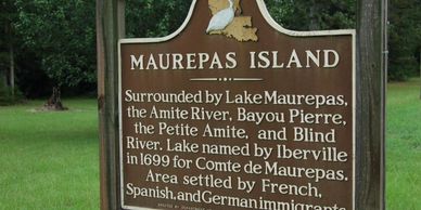
"Maurepas Island" likely refers to a historic area in Louisiana that is now part of the mainland, surrounded by water bodies like Lake Maurepas and the Amite River. The name is also associated with the nearby town of Maurepas, Louisiana, and the vast Maurepas Swamp. While a specific "Maurepas Island" isn't a major landmass today, its historical name is tied to the region's geography and the formation of Lake Maurepas.
Geographic and Historical context
- Formation: The area was historically known as an island due to its location surrounded by water, including Lake Maurepas, the Amite River, Bayou Pierre, Petite Amite, and Blind River.
- Modern Area: Today, the area includes the town of Maurepas and nearby communities like Head of Island, which are on the mainland.
- Lake Maurepas: The lake itself was named by French explorer Iberville in 1699 for Jean-Frédéric Phélypeaux, comte de Maurepas.
- Historical Significance: The name "Maurepas Island" was used to describe a specific, historically settled area in what is now Livingston Parish.
Related locations
- Maurepas Swamp: A large area of swamp situated between Baton Rouge and New Orleans, which is part of the region and offers opportunities for nature viewing.
- Fort Maurepas: A different historical location, Fort Maurepas was a French colonial fort established in 1699 in what is now Ocean Springs, Mississippi.
The Wetlands of Lakes Pontchartrain and Maurepas: Past, Present and Future
The Wetlands of Lakes Pontchartrain and Maurepas: Past, Present and Future

Environmental review from Canadian Science Publishing...
One of the largest wetlands along the Gulf Coast of North America (ca. 150 000 ha) occurs around the shorelines of Lake Pontchartrain and Lake Maurepas in southeastern Louisiana, just north and west of New Orleans. We provide an introduction to the environmental history of the marshes and swamps in the upper Lake Pontchartrain basin, a review of the existing vegetation patterns and their possible causes, and a discussion of restoration targets and priorities. The Mississippi River produced the St. Bernard Delta 3000–4000 years ago, trapping fresh water to produce both Lake Maurepas and Lake Pontchartrain (Frazier 1967). The natural vegetation of much of the region remains fresh or brackish marshes, mixed with swamps dominated by bald cypress (Taxodium distichum) and tupelo (Nyssa aquatica). Yearly flooding by the Mississippi River was once a major factor controlling vegetation patterns, but these processes have been greatly impaired by the construction of artificial levees for flood control. Humans also removed most of the cypress swamps in a pulse of logging between 1876 and 1956. Continued subsidence of the land, slowly rising sea levels, salinity pulses from hurricanes, and canals from the Gulf of Mexico, add further stress to these wetlands. Over the past century there has been a steady loss of wetland area, and a gradual conversion of fresh water to salt water vegetation types. Biotic processes are also important. An exotic species of mammal, nutria (Myocastor coypus), consumes both aboveground and belowground parts of wetland plants. Reforestation is strictly limited by the combination of salt pulses, competition, and nutria. Alligators are the top predator in this system, but their potential for reducing the impacts of nutria has received minimal attention from biologists. There are many potential future states for this ecosystem. In the extreme case of rising sea level and warmer climate, the area may become a salt and brackish embayment fringed with mangroves. The state closest to historical conditions would be large areas of bald cypress swamp. Two important priorities are to increase flow of freshwater into the system from multiple pulsed fresh water diversions, and to decrease saltwater intrusions by closing canals such as the Mississippi River Gulf Outlet.
Local Family life and Culture
Local Family life and Culture
The Wetlands of Lakes Pontchartrain and Maurepas: Past, Present and Future

The culture surrounding the Lakes Pontchartrain and Maurepas region is defined by a mix of influences—including Native American, French, African, and German—that have shaped family life, which often centers on the water for recreation and livelihood. This includes activities like fishing, crabbing, and swimming at weekend camps, a tradition of neighborly mutual aid, and culinary traditions like gumbo that blended different cultural contributions. In some areas, this close-knit, community-oriented family life contrasts with a history of social inequality, such as the racial violence faced by Black residents in the early 20th century. Influences and traditions
- Multicultural heritage: The region's culture is a blend of traditions brought by Native Americans, French colonists, African slaves, and German immigrants.
- Family life on the water: Family life historically revolved around the lakes, with activities like crabbing, swimming, and playing cards at weekend camps being central to recreation and social life.
- Community and mutual aid: Especially in older neighborhoods like Pontchartrain Park, a strong sense of community and mutual support among families was common, similar to a barter system for skills like carpentry and tiling, according to the Preservation Resource Center of New Orleans.
- Culinary traditions: The mix of cultures is evident in the food, with dishes like gumbo blending ingredients and techniques from different groups. For instance, roux came from the French, and filé powder from Native Americans.
- Livelihood: For many, the lakes have been a source of livelihood through fishing, and the area has a strong cultural connection to the waterways.
- Cultural landmarks: The built landscape reflects this heritage, from the unique shotgun house design originating in Africa to log construction in the Florida Parishes.
Historical context and contrasts
- Pioneer-era life: Life in some areas, such as the German settlements along the lake shore, developed from pioneer farming and lumbering communities, as noted by the Historic New Orleans Collection.
- Social inequality: Despite the strong sense of community, some areas like the communities around Ruddock and Frenier, had a history of deeply entrenched white supremacy and racist violence against Black residents.
- Post-Civil War changes: The region saw shifts in power dynamics following the Civil War, with communities like Destrehan Plantation serving roles for freedmen's bureaus, as outlined by the USGS.
Modern Traditions
Local Family life and Culture
Modern Traditions

Nestled just west of Lake Pontchartrain in southeastern Louisiana, Lake Maurepas represents more than just a scenic estuary—it is a thriving hub of water-based traditions and community vitality. The lake’s shallow, brackish waters draw boaters, anglers, and adventurers year-round, but one of the most magnetic draws is the rhythm of the annual “poker run” events that wind through the lake and its connected waterways. One standout example, the Amite 100 Poker Run organized by the Baton Rouge Boat Club, covers roughly one hundred miles, often with stops at beloved local venues such as Blind River Bar and the Canal Bank Club, and serves not only as a fun-loving boating tradition but as a major fundraiser for charitable causes. Unfiltered with Kiran+2Unfiltered with Kiran+2 With hundreds of participants arriving by boat—some traveling long distances—the event creates a lively influx of visitors who fuel local marinas, restaurants, lodging, and service businesses. At the same time, the social ritual of gathering at docks, fueling up, loading hands and sharing stories fosters local culture: families who’ve been participating for decades, new visitors drawing in from around the region, and a blend of serious boaters and casual cruisers all drawn together in the shared experience of lake life. On top of all that, the events help showcase “our” version of Louisiana hospitality and water-culture to outsiders: the dockside jamborees, live music at floating bars, friendly competition, and genuine local pride—all welcome ambassadors to the world. In short, Lake Maurepas is not just the backdrop—it’s the stage where community, economy, and tradition meet to create something distinct, drawing attention and appreciation from near and far.
The attached photo is drone footage of boaters gathering in Lake Maurepas.
Local Cuisine
Local Family life and Culture
Modern Traditions

From the shores of Lake Maurepas, the culinary experience draws from the rich swamps, wetlands and fishing culture of southeastern Louisiana. Local favorites begin with fresh-caught seafood—think thin-fried catfish fillets that have become legendary for their crispy, golden crust and humble, authentic roots. One iconic lakeside spot still follows the same recipe passed down from the 1930s. Beyond fried fish, the region’s food reflects the broader Cajun/Creole heritage of Louisiana—dishes built from the “holy trinity” of onions, bell pepper and celery, seasoned stocks, rice and fresh local produce. Classic stews such as gumbo and jambalaya share space on tables alongside hearty vegetable braises like maque choux, combining corn, peppers, onion and even crawfish or shrimp when available. Together, these foods aren’t just sustenance—they’re a way of life: rooted in place, shaped by the lake’s rhythms, the boats and the harvesting of the marsh. As visitors pull up to docks, grab a lakeside meal, or take in the sunset over the water, they’re tasting more than a dish—they’re participating in a tradition, an invitation into the local culture of Lake Maurepas.
The attached photo is from Middendorf's a locally famous restaraunt showing the traditional thin fried catfish.

SIGN THE PETITION!
Sign the Petition to stop the carbon capture in our beautiful Lake Maurepas!